Portland Then/Now: SW Washington St. & Downtown Waterfront


Thursday, May 28, 2015
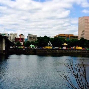
View of SW Washington Street looking west from the water, circa 1927: City of Portland Archives. A2004-002.5653 View of SW Washington Street looking west from the water. May, 2015. Photo by Byron Beck.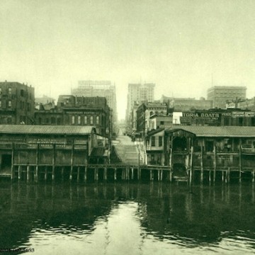
THEN: This is a view of the waterfront and SW Washington Street, looking west from the Willamette River, circa 1927. Or is it? There's a debate on vintageportland.com on whether this was shot at the end of Southwest Washington Street or Alder Street. Which ever one, this particular image catches the street ending at the edge of the waterfront.
In the background you can see buildings that are still standing including the Spaulding, Dekum and Yeon Buildings. This photograph was shot prior to the seawall being erected and shows just how close downtown was to the actual waterfront and its infamous Shanghai Tunnels.
NOW: Downtown's waterfront has changed dramatically over the years and now is home to Tom McCall Waterfront Park. But the park didn't come easy, or for a long time. According to portlandoregon.gov the "idea for this park came at the turn of the century when the 1903 Olmsted Report pointed out the need not only for parks within the city, but for a greenway scheme for the riverbanks in order to ensure their preservation for future generations. The 1912 Bennett Plan again showed a need for more parks and river greenways, but instead of reorienting itself to the river, the city's focus was pulled further inland. In the late 1920s (after this photo was taken) the seawall was built along the Willamette's west bank for the protection of downtown from the annual floods. The seawall not only cut off the water from the people, but the people from the water as well. The construction of Harbor Drive along the west bank in the 1940s continued the trend of isolating the public from the river.
With the opening of the Eastbank Freeway (Marquam Bridge, I-5), Harbor Drive became less important to the traffic flow of the city. Governor Tom McCall created the Harbor Drive Task Force in 1968 in order to study proposals for creating a public open space in its place. In 1974, Harbor Drive was torn up and construction of a waterfront park began. It was completed and dedicated in 1978, gaining instant popularity. In 1984, the park was renamed Governor Tom McCall Waterfront Park."
The park is home to numerous summertime events including the Rose Festival's annual CityFair pictured here in May 2015.
Related Articles
- Portland Then/Now: Southwest Fourth Avenue & Madison Street
- Portland Then/Now: Southwest Fourth Avenue and Morrison Street
- Portland Then/Now: Southwest Park Ave. and Yamhill Street
- Portland Then/Now: Southwest Fourth Ave. & Yamhill St.
- Portland Then/Now: Southwest Fifth Avenue
- Portland Then/Now: Southwest Broadway and Taylor Street
- Portland Then/Now: Southwest Broadway and Washington Street
- Portland Then/Now: Southwest College Street & Sixth Avenue
- Portland Then/Now: Southwest Park Avenue & Taylor Street
- Portland Then/Now: Southwest Second Ave. & Burnside St.
- Portland Then/Now: Union Station
- Portland Then/Now: West Burnside St. and Southwest 10th Ave.
- Portland Then/Now: West Burnside St. and Southwest 18th Ave.
- Portland Then/Now: Tom McCall Waterfront Park
- Portland Then/Now: The Portland Hotel/Pioneer Courthouse Square
- Portland Then/Now: Southwest Third Ave. and Burnside St.
- Portland Then/Now: SW Park Ave. & Yamhill & Taylor St.
- Portland Then/Now: The Corner of Southwest 11th Avenue & Morrison Street
- Portland Then/Now: Southwest Broadway and Morrison Street
- Portland Then/Now: Southwest 2nd Ave. and Yamhill Street
- Portland Then/Now: Northwest 12th Avenue and Lovejoy Street
- Portland Then/Now: Northwest Broadway and Everett Street
- Portland Then/Now: Northwest Couch Street and Third Avenue
- Portland Then/Now: North Lombard St. and Portsmouth Ave.
- Portland Then/Now: Multnomah County Central Library
- Portland Then/Now: East Burnside and 8th Avenue
- Portland Then/Now: Hawthorne Bridge
- Portland Then/Now: Mill Ends Park
- Portland Then/Now: NW Couch St. & Second Ave.
- Portland Then/Now: Pioneer Courthouse Square
- Portland Then/Now: South End of Burnside Bridge
- Portland Then/Now: Southwest 10th Ave. and Yamhill Street
- Portland Then/Now: Southwest 11th Ave. and Morrison St.
- Portland Then/Now: SE 82nd Ave. Between Clinton & Division
- Portland Then/Now: Sandy Blvd. & Northeast 24th Ave.
- Portland Then/Now: Portland City Hall
- Portland Then/Now: Portland State University & SW Park Ave.
- Portland Then/Now: Broadway and North Larabee St.


 Delivered Free Every
Follow us on Pinterest Google + Facebook Twitter See It Read It